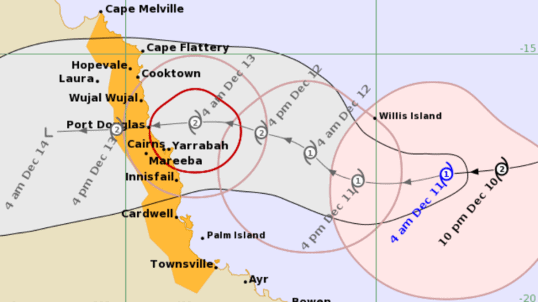
Residents of Queensland’s north and far north coast are being told to prepare for dangerous winds, rainfall, and floods as Cyclone Jasper approaches land.
As of 4am on Monday, the Bureau of Meteorology said the cyclone had weakened to a category one storm but is forecast to re-intensify to a category two as it makes landfall on Wednesday.
Stay up-to-date on the latest news with The National Briefing – keeping you in the loop with news as it hits:
Cape Melville to Townsville, including Cairns, have been included in the BOM’s watch zone.
Cyclone Jasper is then forecast to weaken again as it moves inland on Thursday towards the Gulf of Carpentaria.
The BOM is warning of damaging winds up to 90km/h, developing from Tuesday, with heavy rain also expected to develop along the coast from late Tuesday.
Senior forecaster Shane Kennedy told the ABC parts of northern Queensland will receive rainfall between 50 and 200mm by Wednesday.
“A flood watch is likely to be issued for north-eastern catchments most likely during Monday, potentially Tuesday, just in anticipation of that rain,” he said.
“So certainly, flooding is a fairly common thing we see with tropical cyclones and this one looks to be no exception.”
While residents aren’t panicking about the storm’s potential, people have already flocked to supermarkets to stock up on essential items, including bottled water.
In Cairns, which has not been impacted by a cyclone in decades, the gondolas have been removed from the Esplanade Ferris wheel. The structure is cyclone rated and won’t need to be fully dismantled.
James Cook University has also delayed its Cairns graduation until March next year.
People can stay up to date with the latest cyclone warnings on the Bureau of Meteorology’s website.
